Wild Cherry Tree Campsite, near Mount Torbreck
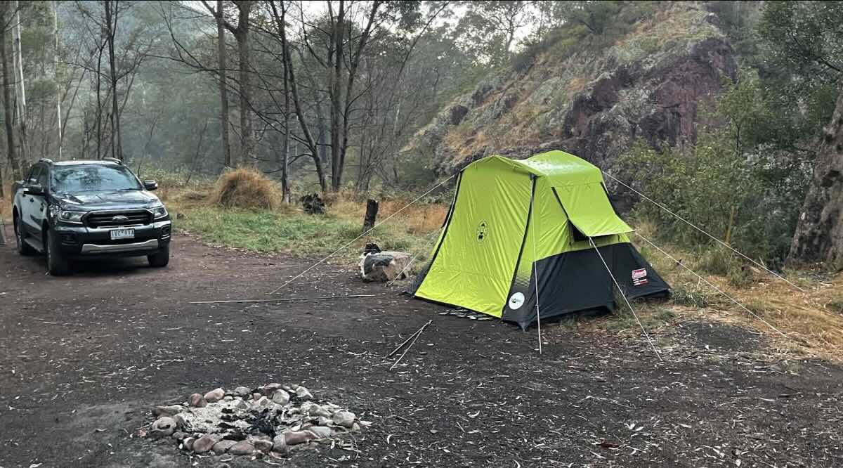
Tucked away in the rugged state forest between Lake Eildon and the Cathedral Range, Wild Cherry Tree Campsite is a destination for the dedicated 4WD explorer. This is not a campground in the conventional sense, but rather a primitive, undeveloped clearing on a challenging off-road track, offering a true sense of isolation. Access is the primary adventure; reaching the site requires a capable high-clearance 4WD and a driver comfortable with steep, rocky, and potentially slippery terrain. The journey itself, through dense eucalyptus forest and mountain ash, is the main drawcard for many visitors. The reward for navigating the demanding tracks is a small, secluded spot where the only sounds are the rustle of leaves and the calls of native birds. This campsite is the antithesis of a holiday park; it’s a place for total self-reliance and immersion in the untamed Victorian bush.Potential campers must understand that “primitive” means a complete lack of facilities. There are no toilets, no picnic tables, no supplied water, and no rubbish collection services. Every item needed for survival and comfort must be carried in, and more importantly, every scrap of waste must be carried out. Adherence to ‘Leave No Trace’ principles is not just encouraged; it is essential to preserve the wild character of this place. The site is a small, natural clearing, best suited for a single vehicle with a rooftop tent, or a couple of swags or small tents. It is not suitable for camper trailers or caravans. Due to its remote location and the difficulty of the access tracks, this campsite should only be attempted by experienced 4WD enthusiasts travelling in a group with appropriate recovery gear and communication devices like a satellite phone or PLB, as mobile reception is non-existent. It’s a challenging but rewarding destination for those seeking solitude and adventure.
Wild Cherry Tree Campsite – VIC Location Map
- Name and Address: Wild Cherry Tree Campsite, Wild Cherry Tree Track, Eildon, VIC 3713, Australia
- GPS Coordinates: -37.55509762639285, 146.61842638108914
Campground Information & Features
- Location: Remote state forest location on the Wild Cherry Tree Track, in the general area between Lake Eildon and Mount Torbreck.
- Site Suitable For: Tents, swags, rooftop tents. Not suitable for trailers.
- Road Access: Strict 4WD only. Tracks are very challenging, steep, and can be impassable when wet. For experienced drivers with recovery gear.
- Site Surface: Natural earth clearing.
- Camping Permitted: Yes, informal bush camping is permitted.
- Maximum Overnight Stays: Not specified; intended for short stays.
- Facilities: None. This is a completely undeveloped site.
- Potable Water: No. You must carry in all your water.
- Mobile Phone Coverage: None. Satellite communication device is essential.
- Onsite Public Toilets: No. A portable toilet and waste disposal system is mandatory.
- Rubbish Bins: No. Strict carry-in, carry-out policy.
- Open Fires: Permitted subject to local fire restrictions and Total Fire Bans. Use extreme caution and ensure fully extinguished.
- Generator Use: Not recommended.
- Number of Sites Available: Very limited space for one or two vehicles.
- Essentials to Bring: All water, food, fuel, full vehicle recovery gear, satellite communicator, portable toilet, rubbish bags, chainsaw, first-aid kit.
- Pet Friendly: Yes, dogs are generally permitted in State Forests but must be under effective control.
- Fishing: Not directly at the campsite. Nearby rivers like the Goulburn or Big River are accessible via other tracks.
- Short Walks: Hiking opportunities on the surrounding 4WD tracks, including routes towards Mount Torbreck.
Nearby Amenities & Attractions (All Distant)
- Local Pubs:
- Jamieson Brewery and Grill (Jamieson) – Approx. 40 km via main roads/tracks
- Eildon Hotel (Eildon) – Approx. 45 km
- Kevington Hotel (Kevington) – Approx. 35 km via 4WD tracks
- Places to Eat:
- Eildon Bakery Cafe (Eildon) – Approx. 45 km
- Jamieson Courtyard Cafe (Jamieson) – Approx. 40 km
- Alexandra (various options) – Approx. 60 km
- Local Attractions:
- Mount Torbreck Summit Track – Nearby
- Lake Eildon National Park – Approx. 25 km
- Cathedral Range State Park – Approx. 30 km
- Nearest Caravan Parks:
- Eildon Pondage Holiday Park (Eildon) – Approx. 45 km
- Jamieson Caravan Park (Jamieson) – Approx. 40 km
- Next Free Camps:
- The Pines Camping Area (near Jamieson) – Approx. 30 km
- Numerous informal sites in the surrounding state forest
- Nearest Dump Points:
- Bluegums Riverside Holiday Park (Eildon) – Approx. 45 km
- Alexandra Public Dump Point – Approx. 60 km
- Nearest Petrol Station:
- Eildon (Simpsons Fuel) – Approx. 45 km
- Alexandra – Approx. 60 km
- Drinking Water Resupply:
- Eildon (public taps) – Approx. 45 km
- Alexandra – Approx. 60 km
- Nearest Public Toilets (offsite):
- Barnewall Plains or Mount Torbreck trailheads may have basic toilets.
- Eildon township – Approx. 45 km
Seasonal Weather Forecast, Eildon/Mount Torbreck Area
- Summer (Dec-Feb): Warm to hot days, but cooler at elevation. High fire danger. Tracks can be very dusty. Temperatures range from 12°C to 30°C+.
- Autumn (Mar-May): Mild days and cool nights. Generally good for 4WDing, but tracks can become slippery after rain.
- Winter (Jun-Aug): Cold, wet, and potential for snow at higher elevations. Many tracks become impassable and are subject to seasonal closures. Not recommended for access.
- Spring (Sep-Nov): Cool and variable. Tracks are often wet and slippery from winter runoff and can remain closed until late spring. Check for road closures before attempting.