Walkerville Foreshore Camping Reserve, Coastal Camping South Gippsland VIC
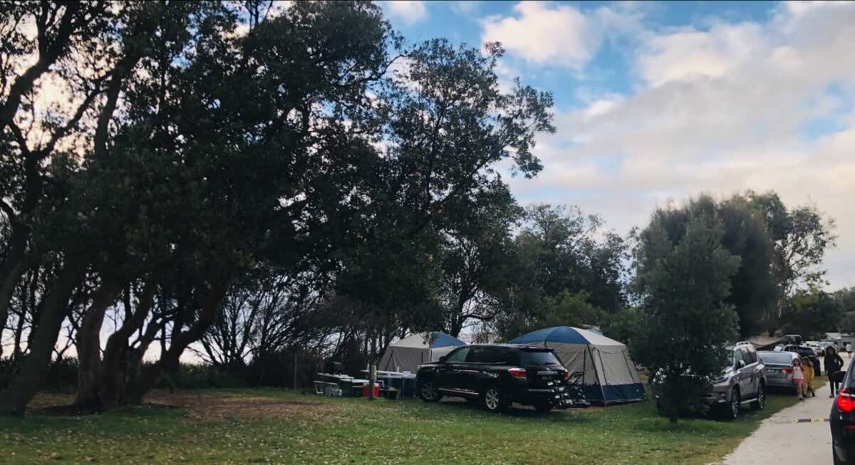
Experience classic coastal camping nestled amongst Banksia woodlands at the Walkerville Foreshore Camping Reserve, located in the scenic Cape Liptrap Coastal Park in South Gippsland, Victoria. This popular reserve offers direct access to the sheltered beaches of Waratah Bay, with stunning views across the water towards Wilsons Promontory National Park. Ideal for families, swimmers, kayakers, and those looking to explore the region’s unique history and natural beauty, Walkerville provides a picturesque and relaxed camping environment. Divided into two main sections, North Walkerville and South Walkerville, the campground caters primarily to tents and smaller camper trailers, offering a back-to-basics coastal escape. Explore rock pools at low tide, walk the historic Lime Burners Walk, visit the nearby Cape Liptrap Lighthouse, or simply unwind on the sand and soak up the tranquil atmosphere.
The Walkerville Foreshore Camping Reserve provides a quintessential Australian beach camping experience. Sites are generally unpowered and located amongst coastal vegetation on sandy or grassy surfaces, offering varying degrees of shade and privacy. Bookings are essential, especially during peak periods, and are managed through the Parks Victoria booking system. Facilities are basic but well-maintained, typically including non-flushing toilets, shared picnic tables, and communal fireplaces or designated fire pits (strict fire regulations apply – check seasonal bans and bring your own firewood). It’s crucial to note that there is usually NO potable (drinking) water available onsite; campers must bring their own sufficient supply for drinking and cooking. While BBQs might be present in picnic areas, campers usually rely on their own cooking equipment. Due to its location within a coastal park, pets are generally not permitted, and rubbish must be taken out with you (carry-in, carry-out policy). Access is via sealed roads, though internal camp roads might be gravel or sand.
Walkerville is steeped in history, most notably the remnants of the historic lime kilns, which can be explored via the Lime Burners Walk connecting North and South Walkerville (check track status for any closures due to erosion). The sheltered bay beaches are perfect for swimming, snorkelling, kayaking, and paddleboarding. Fishing from the rocks or beach can also be rewarding. For stunning coastal views, take a drive out to the Cape Liptrap Lighthouse. The campground serves as a great base for exploring further afield into Wilsons Promontory National Park (allow ample driving time) or visiting nearby towns like Tarwin Lower, Fish Creek (home to art galleries and cafes), and Foster for supplies and dining. Remember to be prepared for variable coastal weather and limited mobile phone reception in certain areas.
Walkerville Foreshore Camping Reserve – VIC Location Map
Campground Information
Name: Walkerville Foreshore Camping Reserve (Part of Cape Liptrap Coastal Park)
Address: Loop Rd, Walkerville North VIC 3956 (Address points generally to the North Walkerville section)
Website: www.walkervilleforeshore.com.au
GPS Coordinates: -38.83993, 146.00058 (Approximate location for North Walkerville)
Site Details
- Location: Walkerville North/South, South Gippsland coast, within Cape Liptrap Coastal Park, overlooking Waratah Bay.
- Site Suitable For: Tents, camper trailers, small campervans. Some sites may accommodate small caravans, but access can be tight and uneven – check site descriptions carefully when booking.
- Road Access: Sealed roads to Walkerville. Internal loop roads within the campground are typically gravel/sand.
- Site Surface: Sand, grass, natural ground, often uneven.
- Camping Permitted: Yes, bookings essential via Parks Victoria.
- Maximum Overnight Stays: Limits may apply, especially during peak season (check Parks Victoria booking site).
Facilities and Features
- Picnic Tables: Yes, shared tables available in communal areas.
- Potable Water: No, typically non-potable water only (if available). You MUST bring your own drinking water.
- Mobile Phone Coverage: Limited and unreliable. Telstra usually offers the best chance of some reception in specific spots, but do not rely on it.
- TV Reception: Poor to non-existent.
- BBQ’s: Communal wood fireplaces/pits are usually available (BYO wood). Shared electric/gas BBQs may be present in some day-use areas but not guaranteed at campsites.
- Onsite Public Toilets: Yes, non-flushing (pit/composting) toilets are available.
- Ullage (Dump Point): No onsite dump point. Nearest public dump points are in larger towns.
- Drive Through Sites: No, sites are generally smaller and require reversing/manoeuvring.
- Rubbish Bins: No, this is a carry-in, carry-out area. You must take all rubbish with you.
- Open Fires: Permitted only in designated fireplaces/pits, subject to seasonal fire restrictions (Total Fire Ban days prohibit all fires). BYO firewood (collecting firewood is prohibited).
- Generator Use: No, generators are prohibited.
- Number of Sites Available: Check Parks Victoria booking system for site numbers in North and South sections.
- Essentials to Bring: Drinking water (crucial!), firewood (if fires permitted), cooking equipment, camp chairs, insect repellent, sun protection, first-aid kit, rubbish bags.
- Pet Friendly: No, pets are not permitted within the campground or Cape Liptrap Coastal Park.
- Fishing: Yes, beach and rock fishing popular in Waratah Bay.
- Short Walks: Yes, Lime Burners Walk (check status), beach walks, tracks within Cape Liptrap Coastal Park.
Local Amenities (Distances approximate from Walkerville North)
Pubs
- Fish Creek Hotel: (Approx. 25 km) – Iconic art deco pub in Fish Creek.
- Tarwin Lower Hotel: (Approx. 27 km) – Pub in the nearby coastal town.
- Foster Exchange Hotel: (Approx. 35 km) – Pub in the larger town of Foster.
Places to Eat
- Walkerville Kiosk (Seasonal): (Approx. 1-2 km) – Basic snacks/drinks often available during peak season near the boat ramp.
- Cafes in Fish Creek: (Approx. 25 km) – Options like Long John Pickles, Little Oberon Cafe.
- Cafes/Takeaways in Tarwin Lower: (Approx. 27 km) – Basic options available.
- Pubs/Cafes/Bakeries/Supermarkets in Foster: (Approx. 35 km) – Wider range of dining and supply options.
Local Attractions
- Walkerville Lime Kilns & Cemetery: (Approx. 1-2 km) – Historic remnants accessible via walk or short drive.
- Cape Liptrap Lighthouse: (Approx. 15 km) – Historic lighthouse with stunning coastal views (grounds accessible).
- Bear Gully Campground & Beach: (Approx. 5 km) – Nearby coastal camping area (also Parks Vic, bookings required).
- Waratah Bay township: (Approx. 15 km) – Small coastal settlement.
- Wilsons Promontory National Park Entrance Gate: (Approx. 40 km via Yanakie) – Gateway to the famous national park (allow extra travel time to Tidal River).
Nearest Caravan Parks
- Waratah Bay Caravan Park: (Approx. 15 km) – Offers powered sites and more facilities.
- Yanakie Caravan Parks (e.g., BIG4 Wilsons Prom, Yanakie Caravan Park): (Approx. 25-30 km) – Closest options near the Prom entrance.
Nearest Free Camps
- Bear Gully Campground: (Approx. 5 km) – Note: This is NOT free, requires Parks Vic booking and fees.
- Agnes River Rest Area (Agnes): (Approx. 50 km North) – Basic roadside rest area, suitable for self-contained vehicles, check current restrictions.
- Note: True free camping options are limited in this popular coastal region.
Nearest Dump Points
- Walkerville Transfer Station: (Approx. 5 km towards Fish Creek) – Council waste facility, may offer dump point access during opening hours (confirm availability and fees).
- Foster Public Dump Point: (Approx. 35 km) – Located in Foster, often near the BP service station or showgrounds.
- Tarwin Lower Dump Point: (Approx. 27 km) – May have facilities, check near foreshore or caravan park.
Nearest Petrol Stations
- Fish Creek Roadhouse/Service Station: (Approx. 25 km).
- Tarwin Lower Service Station: (Approx. 27 km).
- Foster Service Stations (Multiple): (Approx. 35 km).
Nearest Drinking Water Resupply
- Campers MUST bring their own initial supply.
- Foster Visitor Information Centre or Public Taps: (Approx. 35 km) – Reliable source for refilling containers.
- Fish Creek Public Taps: (Approx. 25 km) – Check parks or public facilities.
Nearest Public Toilets (Outside Campground)
- Walkerville Boat Ramp/Picnic Area: (Approx. 1-2 km) – Public toilets usually available near the South Walkerville boat ramp.
- Cape Liptrap Lighthouse Carpark: (Approx. 15 km) – Toilets often available here.
- Fish Creek Town Centre: (Approx. 25 km).
Seasonal Weather Forecast: Walkerville / Cape Liptrap (South Gippsland Coast)
Summer (December – February)
- Warm to occasionally hot days, mild nights. Often influenced by sea breezes, can be cooler than inland areas.
- Mean Max: 22°C – 24°C (Can reach low 30s)
- Mean Min: 13°C – 14°C
- Mean Rain (mm): 40-50 mm
- Mean Rain Days: 7-9
Autumn (March – May)
- Mild days cooling down, cool nights. Can have beautiful calm, sunny periods.
- Mean Max: Cools from 22°C down to 16°C.
- Mean Min: Cools from 13°C down to 9°C.
- Mean Rain (mm): 50-80 mm
- Mean Rain Days: 10-14
Winter (June – August)
- Cool, often windy and showery days, cold nights. Exposed to southerly winds.
- Mean Max: 13°C – 14°C
- Mean Min: 7°C – 8°C
- Mean Rain (mm): 80-100 mm
- Mean Rain Days: 16-19 (Wettest and windiest period)
Spring (September – November)
- Cool to mild days warming up, cool nights. Very changeable weather, often windy with showers and sunny breaks.
- Mean Max: Warms from 16°C up to 19°C.
- Mean Min: Warms from 8°C up to 11°C.
- Mean Rain (mm): 60-80 mm
- Mean Rain Days: 13-16