Moleside Canoe Camping Area (Glenelg River) VIC
Moleside Canoe Camping Area offers a unique position within Victoria’s Lower Glenelg National Park, providing riverside tranquillity accessible by both vehicle and canoe. Located near Drik Drik, roughly halfway between Dartmoor and Nelson along the Glenelg River, Moleside serves as a popular starting or finishing point for sections of the Glenelg River Canoe Trail, as well as a destination for car-based campers seeking a peaceful bush setting. Its dual accessibility makes it more versatile than the dedicated canoe-only camps.
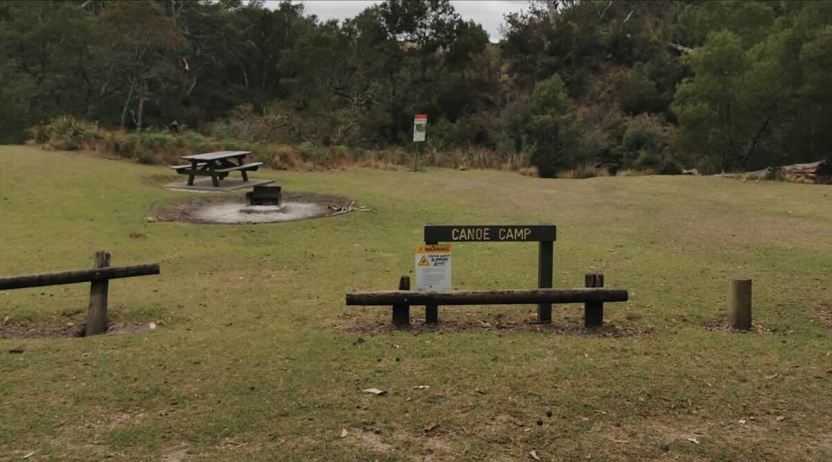
The campground is set amongst bushland, offering shade and shelter. Facilities cater to both canoeists and vehicle-based campers, featuring designated sites often equipped with picnic tables and shared wood fire pits (subject to fire restrictions). Non-flush (drop) toilets are available for campers’ convenience. Moleside is also a designated landing point, allowing easy launch and retrieval of canoes and kayaks. While a non-potable rainwater tank may be present, campers must bring their own drinking water supply or means of water treatment.
Like all campgrounds within the Lower Glenelg National Park, **booking through Parks Victoria is essential** and camping fees apply. National Park regulations are strictly enforced: **dogs and other pets are prohibited**, generators are not permitted, and fires are restricted to the provided fireplaces (BYO firewood). All rubbish must be carried out by visitors – Leave No Trace principles are paramount. Access is via unsealed park roads, generally suitable for 2WD vehicles in dry conditions but caution is advised, especially after rain. Mobile phone reception is typically unavailable or very unreliable in the area.
Moleside Camping Area provides an excellent base for exploring this section of the Glenelg River, whether by paddling downstream towards Nelson, fishing for bream and mulloway, or hiking sections of the Great South West Walk which passes nearby. Its vehicle access allows for greater comfort and convenience compared to the hike-in/paddle-in sites, making it a good option for families or those carrying more gear. Remember to book in advance and arrive fully self-sufficient for a rewarding stay by the serene Glenelg River.
Moleside Canoe Camping Area – VIC Location Map
Campsite Details
Name: Moleside Camping Area (also referred to as Moleside Canoe Camp or Moleside Landing)
Address: Moleside Track, Lower Glenelg National Park, Drik Drik VIC 3304
GPS Coordinates: -38.05449, 141.26875
Website: Parks Victoria Bookings
Site Features
- Location: Lower Glenelg National Park, on the banks of the Glenelg River, near Drik Drik.
- Site suitable for: Tents, camper trailers, small caravans/RVs, canoes/kayaks.
- Road access: Yes, via unsealed Moleside Track. Generally 2WD accessible in dry conditions, caution needed when wet. Also accessible via river.
- Site surface: Natural earth/grass clearings.
- Camping permitted: Yes, **bookings essential via Parks Victoria (fees apply).**
- Maximum overnight stays: Determined by booking.
- Picnic tables: Yes, shared tables available.
- Potable water: **No.** Untreated rainwater tank may be onsite (boil/treat before use). Bring your own water.
- Mobile phone coverage: **None / Very Unreliable.**
- TV reception: No.
- Onsite public toilets: **Yes, non-flush (drop) toilets.**
- Rubbish bins: **No.** Pack-in, pack-out essential.
- Open fires: Permitted in designated fire pits only. Subject to seasonal fire restrictions (Total Fire Bans). BYO firewood.
- Generator use: **Not permitted** (National Park).
- Number of sites available: 15 designated sites (check booking system).
- Essentials to bring: **Drinking water/treatment method,** all food, stove, rubbish bags, firewood, toilet paper, first-aid kit, insect repellent.
- Pet friendly: **NO. Dogs and pets are not permitted** in the Lower Glenelg National Park.
- Fishing: Yes (Victorian fishing licence required).
- Short walks: Yes, access to the Great South West Walk and riverbank exploration.
Local Amenities (Nearest town: Nelson ~30km / Dartmoor ~25km)
Distances are approximate by road.
Local Pubs
- Nelson Hotel: Approximately 30-35km away in Nelson.
- Dartmoor Hotel: Approximately 25-30km away in Dartmoor.
- *Note: Drik Drik does not have a pub.*
Places to Eat
- Nelson Kiosk / Cafe: Approximately 30-35km away in Nelson.
- Dartmoor General Store / Roadhouse: Basic supplies/takeaway (approx. 25-30km).
Local Attractions
- Princess Margaret Rose Cave: Limestone cave tours (closer to Nelson).
- Glenelg River Cruises: Tours depart from Nelson.
- Great South West Walk: Passes nearby.
- Fort O’Hare (Dartmoor): Historical site.
Nearest Caravan Parks
- Kywong Caravan Park: Approximately 30-35km away in Nelson.
- Nelson Riverfront Holiday Park: Approximately 30-35km away in Nelson.
- Dartmoor Caravan Park: Approximately 25-30km away in Dartmoor.
Next Free Camps (Vehicle Accessible / Note Rules)
- *Note: Check WikiCamps or similar apps for potential basic roadside stops outside the national park. Rules vary.*
- *Campsites within Cobboboonee Forest Park (nearby) allow dogs.*
Next Camps (Canoe Access Only)
- Skipworth Springs Canoe Camp: Downstream (closer to Nelson).
- Lasletts Canoe Camp: Upstream (further from Nelson).
Nearest Dump Points
- Nelson Kiosk / Public Toilets Area: Public RV dump point (approx. 30-35km).
- Dartmoor Caravan Park: May offer dump point access (check first, approx. 25-30km).
- Mount Gambier (SA): Larger town facilities (approx. 60-70km).
Nearest Petrol Station
- Nelson Roadhouse / General Store: Approximately 30-35km away in Nelson.
- Dartmoor Roadhouse / General Store: Approximately 25-30km away in Dartmoor.
Drinking Water Resupply
- Nelson Kiosk / Public Toilets Area: Potable water taps available (approx. 30-35km).
- Dartmoor: Public taps may be available (check locally, approx. 25-30km).
Nearest Public Toilets (Vehicle Accessible)
- Nelson Boat Ramp / Kiosk Area: Public toilets available (approx. 30-35km).
- Dartmoor Town Centre / Recreation Reserve: Public toilets available (approx. 25-30km).
Seasonal Weather Forecast (Nelson/Dartmoor Area)
- Summer (December – February): Mild to warm days, often breezy. Average highs around 22-25°C, lows around 12-14°C.
- Autumn (March – May): Mild becoming cool. Clear days common, cooler nights. Highs drop from 23°C to 16°C.
- Winter (June – August): Cool, damp, and often cloudy. Average highs around 13-15°C, lows around 6-7°C. Expect rain.
- Spring (September – November): Cool becoming mild. Weather can be variable with wind and showers. Highs rise from 16°C to 21°C.