Jardine Ferry – The Final Frontier on Your Cape York Adventure
For the dedicated adventurer, reaching the Jardine Ferry Crossing is a true rite of passage. This is not just another campground; it is the legendary final staging post on the epic overland journey to the northernmost tip of the Australian continent. Located in a rugged and remote wilderness setting on the southern bank of the mighty Jardine River, this park serves as the crucial basecamp for all travellers preparing to cross the ferry and enter the Northern Peninsula Area (NPA). The atmosphere here is one of raw adventure and shared accomplishment, a dusty hub where well-equipped rigs and seasoned explorers gather to swap tales from the challenging Old Telegraph Track and prepare for the final push to The Tip.This is a place to embrace the wild. The park offers a basic but welcome sanctuary after days on corrugated roads, providing essential amenities in a spectacular natural setting. The mighty Jardine River itself, a beautiful but crocodile-inhabited waterway, is the main feature, and the iconic vehicular ferry is the only way across. A stay here allows you to rest, check your vehicle, and get an early start for the ferry crossing. The area is a paradise for keen anglers, with the river system renowned for its barramundi and saratoga (be croc-wise at all times). It’s a place to reset, appreciate the incredible remoteness of your location, and soak in the true spirit of a Cape York expedition. For anyone undertaking this ultimate Australian road trip, a stop at the Jardine Ferry Caravan Park is an essential and unforgettable part of the adventure.
Jardine Ferry – QLD Location Map
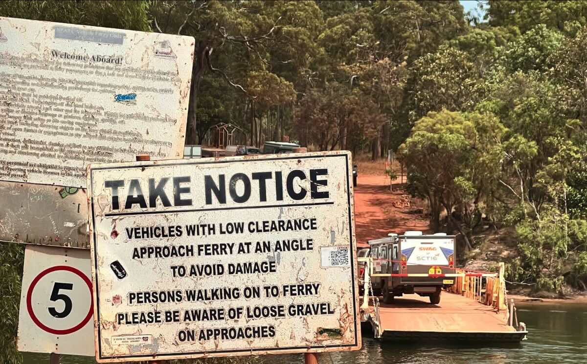
Jardine Ferry Crossing
Address: Northern Bypass Rd, Jardine River QLD 4876
Website: www.nparc.qld.gov.au/Our-services/Jardine-Ferry
GPS Coordinates: -11.1038, 142.28396
Site Details and Facilities
- Location: Extremely remote wilderness setting on the southern bank of the Jardine River, Cape York Peninsula.
- Site Suitable For: High-clearance 4WD vehicles with tents, camper trailers, and off-road caravans.
- Road Access: Unsealed and often corrugated roads (Peninsula Developmental Road and Bypass Roads). 4WD is essential.
- Site Surface: Natural dirt, sand, and gravel sites in a bush setting.
- Camping Permitted: Yes, unpowered sites are the main offering.
- Maximum Overnight Stays: Caters to tourists and adventurers; most stay 1-2 nights.
- Facilities: Basic amenities block with toilets and cold showers, some BBQ plates. Be prepared to be self-sufficient.
- Picnic Tables: Limited; self-sufficiency is key.
- Potable Water: Yes, bore water is available. It is advisable to boil or filter water.
- Mobile Phone Coverage: None. Satellite phone or personal locator beacon is highly recommended.
- TV Reception: Not available.
- Onsite Public Toilets: Yes.
- Rubbish Bins: Yes, but it is best practice to carry your rubbish out of remote areas.
- Open Fires: Permitted in designated fire pits or your own off-the-ground fire pit, subject to local fire bans.
- Generator Use: Permitted with consideration for others.
Activities & Essentials
- Essentials to Bring: All food, water, fuel, vehicle recovery gear, comprehensive first-aid kit, insect repellent, and a satellite communication device.
- Pet Friendly: No, pets are generally not permitted due to the remote wilderness location and national parks.
- Fishing: Excellent Barramundi and Saratoga fishing in the Jardine River. Be extremely crocodile aware at all times.
- Short Walks: Explore the immediate area around the ferry crossing and campground (stay away from the water’s edge).
Local Amenities
Pubs & Restaurants
- Nearest Hotel (Bamaga Tavern): Approx. 85 km north (after ferry crossing).
- Nearest Roadhouse (Bramwell Station): Approx. 130 km south.
Local Attractions
- Jardine River Ferry Crossing: Onsite.
- Old Telegraph Track (Southern Section): Access points south of the park.
- The Tip of Cape York: Approx. 120 km north (after ferry crossing).
- Fruit Bat Falls & Eliot Falls: Approx. 50 km south (via the OTT).
Camping & Travel Resources
- Nearest Caravan Parks: This is the last park before the NPA. Parks are available in Bamaga/Seisia (approx. 85 km north).
- Next Free Camps: Numerous remote bush camps are available along the PDR and OTT.
- Nearest Dump Points: Facilities are available in Bamaga.
- Nearest Petrol Station: Bramwell Station (south) or Bamaga (north). Carry sufficient jerry cans.
- Drinking Water Resupply: Available onsite (treat before use).
- Public Toilets: Onsite at the camp.
Seasonal Weather Forecast: Cape York Peninsula
- Wet Season (Dec-Apr): Extreme heat and humidity with monsoonal rain. All roads are impassable and the ferry does not operate. Travel is impossible.
- Dry Season (May-Nov): The only time to travel. Days are warm to hot and sunny with low humidity. Nights are mild. The peak season is June to September.