Howqua Gap Hut & Camping Area
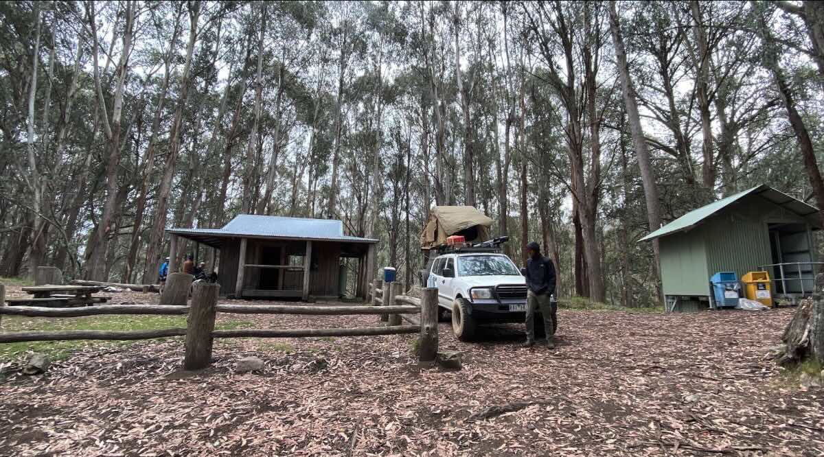
Howqua Gap Hut is a quintessential High Country destination, offering a free, rustic camping experience steeped in the history of Victoria’s cattlemen. Located in a scenic saddle between the popular peaks of Mt Stirling and Mt Buller, this spot is a hub for hikers, horse riders, and 4WD enthusiasts exploring the Alpine National Park. The centerpiece is the historic hut itself, a timber and iron structure providing emergency shelter and a tangible connection to the past. Surrounding the hut is a beautiful, open grassy area that serves as the campground, offering stunning views of the snow gums and alpine plains. Accessing Howqua Gap is part of the adventure; it’s a 4WD-only destination, typically reached via the Circuit Road from Mt Stirling or more challenging tracks from the Howqua Valley. These tracks are subject to seasonal closures, making the campsite primarily a summer and autumn destination.The camping here is basic and self-sufficient. A non-flush toilet is the only facility provided, meaning campers must bring all their own supplies, including drinking water, food, and rubbish bags to carry everything out. As it is situated within the Alpine National Park, strict rules are in place to protect the fragile environment: dogs and generators are not permitted. Fires are allowed in the designated fireplaces, but you must bring your own firewood as collection is prohibited. The hut itself is for temporary and emergency shelter, not for overnight accommodation, so a tent or swag is essential. The location is a hiker’s paradise, sitting directly on the popular walking track that links Mt Stirling’s summit to Mt Buller. It’s also a fantastic base for exploring other iconic High Country locations like Craig’s Hut. For those prepared for a remote, self-reliant adventure, camping at Howqua Gap Hut offers an unforgettable experience in one of Victoria’s most spectacular alpine landscapes.
Howqua Gap Hut & Camping Area – VIC Location Map
- Name and Address: Howqua Gap Hut & Camping Area, Howqua Gap Trail, Mount Buller, VIC 3723, Australia
- GPS Coordinates: -37.14450525557459, 146.4906387631718
- Website: Parks Victoria – Alpine National Park
Campground Information & Features
- Location: In the saddle between Mt Buller and Mt Stirling in the Alpine National Park.
- Site Suitable For: Tents, swags, and small off-road camper trailers.
- Road Access: 4WD only. Tracks are steep, rough, and subject to seasonal closures (usually June-November).
- Site Surface: Grassy alpine clearing.
- Camping Permitted: Yes, free camping is permitted in the area around the hut.
- Maximum Overnight Stays: Standard national park limits apply.
- Facilities: Non-flush toilet, historic hut for emergency shelter only.
- Potable Water: No. Bring all your own water. There may be a small creek or water tank, but supply is unreliable and requires treatment.
- Mobile Phone Coverage: Unlikely to have coverage.
- Onsite Public Toilets: Yes, a basic non-flush toilet is available.
- Rubbish Bins: No. All rubbish must be carried out.
- Open Fires: Permitted in designated fireplaces only, subject to fire bans. No firewood collection allowed.
- Generator Use: Prohibited in the Alpine National Park.
- Number of Sites Available: Several unmarked sites in the clearing.
- Essentials to Bring: All water, firewood, rubbish bags, toilet paper, alpine-rated camping gear, maps.
- Pet Friendly: No. Pets are not permitted in the Alpine National Park.
- Fishing: Not applicable at this high-altitude location.
- Short Walks: Excellent. It is on the main trail between Mt Stirling and Mt Buller. The walk to the Mt Stirling summit is a popular option.
Nearby Amenities & Attractions
- Local Pubs:
- The Arlberg Hotel (Mt Buller Village) – Approx. 8 km (via 4WD/hike)
- The Delatite Hotel (Mansfield) – Approx. 55 km
- Merrijig Motor Inn (Merrijig) – Approx. 40 km
- Places to Eat:
- Mt Buller Alpine Village (Various restaurants, seasonal) – Approx. 8 km
- Merrijig (Pub bistro) – Approx. 40 km
- Mansfield (Wide range of cafes, pubs, restaurants) – Approx. 55 km
- Local Attractions:
- Mt Buller Summit & Village
- Mt Stirling Summit & Trail Network
- Craig’s Hut (via another 4WD track)
- Nearest Caravan Parks:
- Mansfield Holiday Park – Approx. 55 km
- Howqua Valley Holiday Park – Approx. 45 km
- Next Free Camps:
- Several clearings along the Circuit Road on Mt Stirling
- Sheepyard Flat (2WD accessible) – Approx. 35 km (via 4WD tracks)
- Nearest Dump Points:
- Mansfield Public Dump Point – Approx. 55 km
- Nearest Petrol Station:
- Mansfield (Multiple major stations) – Approx. 55 km
- Drinking Water Resupply:
- Mansfield is the last reliable town for water.
- Nearest Public Toilets (offsite):
- Telephone Box Junction (Mt Stirling)
- Mt Buller Village
Seasonal Weather Forecast: Howqua Gap / Alpine Area
- Summer (Dec-Feb): Days can be warm and sunny but alpine weather is highly unpredictable. Be prepared for cold, wind, and rain at any time.
- Autumn (Mar-May): Often provides the most stable weather with clear, crisp days and cold nights. The alpine landscape is beautiful.
- Winter (Jun-Aug): Inaccessible by vehicle. The area is covered in deep snow and tracks are closed.
- Spring (Sep-Nov): Tracks remain closed until snow melts and they are deemed safe, often not until late November. Cold and variable conditions.