Currawong Camp, Alpine National Park
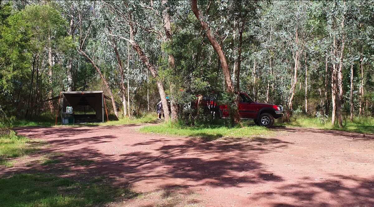
Currawong Camp is a remote bush campsite that offers a true wilderness experience for the self-sufficient 4WD adventurer. Tucked away in the vast Wonnangatta-Moroka section of the Alpine National Park, this is not a destination for the casual camper. Access is via the challenging Moroka Road, a track strictly for high-clearance 4WD vehicles, which is subject to seasonal closures and can be impassable after heavy rain. The journey is rewarded with a small, secluded clearing deep in the high country, offering unparalleled peace and quiet. The campsite is a simple, natural space surrounded by the majestic alpine ash and snow gum forests that define the region, providing an authentic setting for those looking to disconnect and immerse themselves in the rugged beauty of the Victorian Alps.This is primitive camping in its purest form, with a complete absence of facilities. Campers must arrive with everything they need to survive, including a portable toilet, all drinking and washing water, and a robust system for carrying out every piece of rubbish. As the camp is located within the Alpine National Park, strict regulations are in place to protect the fragile ecosystem; pets and generators are strictly forbidden. Fires are also not permitted, so a fuel stove is an essential piece of equipment for cooking. The campsite’s main appeal is its isolation and its role as a base for exploring the surrounding wilderness. It’s a launching point for experienced hikers and 4WD explorers wanting to tackle the trails around the Moroka River, the Pinnacles, and the breathtaking high plains. For those with the right gear, experience, and respect for the environment, Currawong Camp offers a profound sense of solitude and a front-row seat to the untamed splendour of the high country.
Currawong Camp – VIC Location Map
- Name and Address: Currawong Camp, Moroka Road, Wonnangatta, VIC 3862, Australia
- GPS Coordinates: -37.55291039334422, 146.61188316505883
- Website: Parks Victoria – Alpine National Park
Campground Information & Features
- Location: Remote area of the Alpine National Park, off Moroka Road, north of Licola.
- Site Suitable For: Tents and swags only.
- Road Access: 4WD only. Tracks are steep, rough, and subject to seasonal closures (usually June-November).
- Site Surface: Natural forest clearing.
- Camping Permitted: Yes, free dispersed camping.
- Maximum Overnight Stays: Standard national park regulations apply.
- Facilities: None.
- Potable Water: No. You must bring all your own water.
- Mobile Phone Coverage: None. A satellite communication device is essential.
- Onsite Public Toilets: No. A portable toilet must be carried and used.
- Rubbish Bins: No. All rubbish must be carried out.
- Open Fires: Prohibited. Fuel stoves only.
- Generator Use: Prohibited.
- Number of Sites Available: A very small clearing, suitable for 1-2 small groups.
- Essentials to Bring: All water, portable toilet, fuel stove, vehicle recovery gear, detailed maps, PLB/sat phone, first-aid kit.
- Pet Friendly: No. Pets are not permitted in the Alpine National Park.
- Fishing: Possible in the nearby Moroka River, requiring a hike to access.
- Short Walks: This is a base for challenging, remote bushwalks, not short strolls.
Nearby Amenities & Attractions (All are very remote)
- Local Pubs:
- Dargo Hotel (Dargo) – Approx. 60 km (via slow 4WD tracks)
- Licola General Store (Licensed) – Approx. 50 km (via slow 4WD tracks)
- Heyfield Railway Hotel (Heyfield) – Approx. 120 km
- Places to Eat:
- Dargo Hotel / General Store – Approx. 60 km
- Licola General Store – Approx. 50 km
- Local Attractions:
- Moroka River and walking tracks
- The Pinnacles Lookout
- Howitt Plains
- Nearest Caravan Parks:
- Licola Caravan Park – Approx. 50 km
- Dargo River Inn & Tourist Park – Approx. 60 km
- Next Free Camps:
- Horseyard Flat Camping Area – Approx. 10 km
- Numerous small clearings along 4WD tracks in the area.
- Nearest Dump Points:
- Heyfield – Approx. 120 km
- Maffra – Approx. 130 km
- Nearest Petrol Station:
- Licola General Store (unreliable hours, expensive) – Approx. 50 km
- Dargo General Store – Approx. 60 km
- Drinking Water Resupply:
- Licola or Dargo are the last points, but supply can be limited. Heyfield is the last major town.
- Nearest Public Toilets (offsite):
- Horseyard Flat Camping Area may have a non-flush toilet – Approx. 10 km
Seasonal Weather Forecast: Howitt Plains / Alpine Area
- Summer (Dec-Feb): Weather is highly unpredictable. Days can be hot, but cold, wet, and windy conditions can arrive without warning. High fire danger.
- Autumn (Mar-May): Generally the most stable and recommended time for visiting. Expect mild days and cold nights.
- Winter (Jun-Aug): Inaccessible. All tracks are closed due to deep snow and hazardous conditions.
- Spring (Sep-Nov): Tracks typically remain closed until late November. The area is subject to cold, wet, and snowy conditions.