Cricket Pitch Shelter Camping, Mount Stirling – Free Campsite VIC
Discover the rugged beauty of the Victorian High Country with a visit to the Cricket Pitch Shelter on the Stirling Trail. Nestled high on the slopes of Mount Stirling, this site offers a unique and authentic alpine camping experience, transforming dramatically with the seasons. It’s a popular and essential stop for hikers, 4WD enthusiasts, and, in winter, snow campers and cross-country skiers.
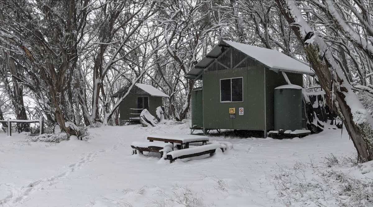
Located within the Mount Stirling Alpine Resort, the Cricket Pitch Shelter serves as a public refuge hut, providing basic facilities and a cleared area for camping. In the green seasons (typically summer and autumn), it is accessible via the unsealed Circuit Road, making it a fantastic base for 4WD touring and exploring the region’s many trails. The road access is suitable for off-road vehicles and high-clearance 4WDs, but not for caravans or large motorhomes. From here, adventurers can tackle the hike to the Mount Stirling Summit for panoramic views or make the pilgrimage to the iconic Craig’s Hut, of “The Man from Snowy River” fame.
During the declared winter season, the site’s character changes completely. The Circuit Road closes, and access is ski-in, ski-out or by snowshoe only, turning it into a true snow camping destination. The shelter provides critical refuge from the elements for experienced alpine adventurers. Alongside the public shelter, this area also hosts a privately operated “Alpine Camp” with pre-booked tents and facilities, so public campers should ensure they set up in the designated public areas.
Facilities are basic, as expected in a remote alpine environment. You will find composting toilets and some picnic tables. Critically, all water must be brought in, as on-site tanks are non-potable and unreliable. All rubbish must be carried out to preserve the pristine environment. Fires are permitted only in designated fireplaces, but strict adherence to seasonal fire bans is essential. Mobile coverage is patchy at best. This is a brilliant, free campsite for the self-sufficient camper looking to immerse themselves in one of Victoria’s most spectacular alpine landscapes.
Cricket Pitch Shelter – VIC Location Map
Campsite Information
- Name: Cricket Pitch Shelter
- Address: Stirling Trail, Mount Buller VIC 3723
- GPS Coordinates: -37.10999, 146.48762
- Website: www.mtstirling.com.au
Campsite Location Map (Satellite View)
Site Features and Amenities
- Location: Mount Stirling Alpine Resort, Victorian High Country
- Site suitable for: Tents, Swags, Snow Camping (winter), 4WD-based camping (seasonal)
- Road access: Unsealed road (Circuit Road). 4WD required or highly recommended. Seasonal road closures apply (ski-in/snowshoe access only in winter). Not suitable for caravans or large motorhomes.
- Site surface: Gravel, Dirt, Snow (in winter)
- Camping permitted: Yes, free camping is permitted in the public area
- Maximum overnight stays: No specified limit, check with Mt Stirling Alpine Resort for any regulations
- Picnic tables: Yes
- Potable water: No. Bring all your own drinking water. Non-potable water may be available from tanks but cannot be relied upon and must be boiled before use.
- Mobile phone coverage: Limited and patchy (Telstra generally offers the best chance of a signal in remote areas, but do not rely on it)
- TV reception: No
- Onsite public toilets: Yes (composting toilets)
- Rubbish bins: No. This is a “take-in, take-out” site. You must carry all your rubbish out with you.
- Open fires: Permitted in designated hut fireplaces or firepits only. Must be attended, and strict compliance with seasonal fire bans is mandatory. Bring your own firewood.
- Generator use: Discouraged. Check resort regulations.
- Number of sites available: Unpowered, un-numbered sites in a cleared area
- Essentials to bring: Drinking water, food, alpine-rated warm/wet weather gear (even in summer), first-aid kit, rubbish bags, firewood (if intending to have a fire), navigation equipment.
- Pet friendly: No. Pets are generally prohibited in the Mount Stirling Alpine Resort and Alpine National Park.
- Fishing: Yes, in nearby rivers such as the Howqua, Delatite, and Goulburn (Victorian fishing licence required).
- Short walks: Yes. The site is on the Stirling Trail, with access to the Mount Stirling Summit Loop and the trail to Craig’s Hut.
Local Amenities
Note: This is a remote alpine site. All amenities are located in the towns of Mansfield (approx. 55km) or Mirimbah (approx. 12km) and Mount Buller Village.
Pubs
- Buller Road Brewery: Approx. 55km (in Mansfield)
- The Mansfield Hotel: Approx. 55km (in Mansfield)
- Jamieson Brewery: Approx. 70km (in Jamieson)
Places to Eat
- Mansfield: Numerous cafes, bakeries, and restaurants (approx. 55km)
- Mount Buller Village: Various restaurants and bars (approx. 15km via trail/seasonal road, access conditions vary)
- Mirimbah Store: Basic supplies and cafe (approx. 12km, at the base of the mountain)
Local Attractions
- Mount Stirling Summit: Walking distance
- Craig’s Hut: Accessible by 4WD or walking trail
- Mount Buller Alpine Village: Skiing, snowboarding, mountain biking, and events
- Howqua Hills Historic Area: Nearby 4WD/hiking access
- Mansfield Zoo: Approx. 60km (in Mansfield)
Nearest Caravan Parks
- Mansfield Holiday Park: Approx. 55km (in Mansfield)
- Jamieson Caravan Park: Approx. 70km (in Jamieson)
Next Free Camps
- Howqua Gap Hut: Nearby on the Circuit Road
- Razorback Hut: Nearby on the Circuit Road
- Sheepyard Flat (Howqua Hills): Approx. 40km
Nearest Dump Points
- Mansfield Holiday Park: Approx. 55km (in Mansfield, check for public access and fees)
Nearest Petrol Station
- Mirimbah Store: Approx. 12km (at the base of the mountain, limited hours, no Alpine Diesel)
- Mansfield: Multiple 24/7 stations (approx. 55km, Alpine Diesel available)
Drinking Water Resupply
- Mansfield: Public taps and supermarkets (approx. 55km)
Nearest Public Toilets (off-site)
- Telephone Box Junction (TBJ): Approx. 3.5km (seasonal access)
- Mirimbah Park: Approx. 12km (at the base of the mountain)
Seasonal Weather Forecast: Mount Buller Region
Note: This is an alpine environment. Weather can change rapidly at any time of year. Always be prepared for cold, wet, and windy conditions, even in summer. Snow can fall unexpectedly.
- Summer (December – February): Generally mild to warm days with cool nights. Average maximum temperatures are around 17°C, with average minimums around 9°C.
- Autumn (March – May): Days become progressively cooler and nights cold. Average maximums drop from 14°C in March to 6°C by May. Average minimums can fall below freezing (0.9°C) by May.
- Winter (June – August): This is the snow season. Conditions are cold, with frequent snowfall. Average maximum temperatures hover between 1.5°C and 3°C, with average minimums dropping to -2.6°C.
- Spring (September – November): The snow begins to melt as temperatures rise. Days are cool, warming from an average max of 5°C in September to 12°C by November. Nights remain very cold, with minimums rising from freezing to around 4.6°C.