Cracknback Riverside Campground, Lower Creek
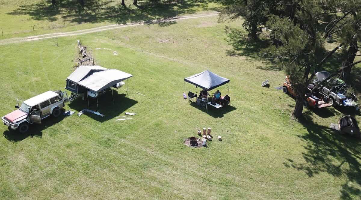
The Cracknback Riverside Campground is a spectacular, secluded, and completely free bush camping spot located on the banks of the Macleay River at Lower Creek. Situated on the legendary Armidale-Kempsey Road, this campground is a true gem for adventurous and self-sufficient travellers seeking to escape into the rugged beauty of the NSW Northern Tablelands. The site is a large, open, grassy flat that stretches along a beautiful section of the river, offering numerous private spots to set up camp. Surrounded by steep, forested hills, it provides an incredible sense of isolation and tranquility.
This is a primitive, back-to-basics campground with very limited facilities, best suited for those who are fully equipped to be self-reliant. Typically, the only amenity is a single long-drop toilet. There is no drinking water, no power, no picnic tables, and no rubbish bins. It is absolutely imperative that all visitors bring their own water and supplies, and strictly adhere to a “leave no trace” camping ethic by taking all rubbish with them. The Kempsey-Armidale Road is a long, winding, and largely unsealed route that can be challenging, especially for large vehicles or after heavy rain, making this destination more suitable for 4WDs, high-clearance vehicles, and robust off-road camper trailers. The reward for navigating the journey is immense: a pristine environment perfect for swimming in the river, fishing for bass, kayaking, or simply relaxing by a campfire under an brilliant, star-filled sky. It’s a quintessential Australian bush camp, far from the crowds and the noise of the coast.
Cracknback Riverside Campground – NSW Location Map
Location Details
Name: Cracknback Riverside Campground
Address: 8476 Armidale – Kempsey Road, Lower Creek NSW 2440, Australia
Website: Cracknback Riverside Campground
GPS Coordinates: -30.74567, 152.28265
Site Information
- Location: On the Armidale-Kempsey Road, in the remote area of Lower Creek, between Armidale and Kempsey.
- Site Suitable For: Fully self-contained 4WDs, tents, and off-road camper trailers. Access is difficult for large caravans and motorhomes.
- Road Access: Long, winding, and mostly unsealed road. Condition is highly weather-dependent.
- Site Surface: Grass and dirt.
- Camping Permitted: Yes, camping is permitted.
- Maximum Overnight Stays: Unknown.
- Picnic Tables: Not available.
- Potable Water: Not available. Bring all your own water. River water must be treated before use.
- Mobile Phone Coverage: Non-existent. A satellite phone or personal locator beacon is essential for safety.
- TV Reception: Not available.
- Onsite Public Toilets: Unkown.
- Ullage / Dump Point: Not available onsite.
- Drive Through: No, it is a large open grassed area.
- Rubbish Bins: Not available. You must take all rubbish out with you.
- Open Fires: Permitted in existing fire pits, subject to local fire restrictions and total fire bans. Bring your own firewood.
- Generator Use: Permitted, but be considerate of the serene natural environment.
- Number of Sites Available: Many unmarked sites across a large area.
- Essentials to Bring: All water, food, power, portable toilet (recommended), rubbish bags, firewood, and emergency communication devices.
- Pet Friendly: Yes, pets are generally permitted but must be kept under strict control.
- Fishing: Excellent freshwater fishing for Australian Bass in the Macleay River. A NSW fishing licence is required.
- Short Walks: Informal walks along the river and through the surrounding bushland.
Local Amenities (Note: All services are a very long drive away)
Pubs & Eateries
- Willawarrin Hotel: Approx. 60km east towards Kempsey.
- The Bellbrook Hotel: Approx. 50km east (detour off main road). A classic, remote country pub.
- The Royal Hotel, Armidale: Approx. 115km west in the nearest major city.
- There are no services at Lower Creek. The nearest major towns for a full range of supplies are Kempsey or Armidale.
Local Attractions
- Macleay River: The primary attraction for swimming, fishing, and kayaking.
- Oxley Wild Rivers National Park: The road passes through parts of this vast World Heritage wilderness area.
- Werrikimbe National Park: Another nearby wilderness area with hiking and lookouts.
Caravanning & Camping Supplies
- Nearest Caravan Parks: Located in Kempsey (approx. 90km east) and Armidale (approx. 115km west).
- Next Free Camps: Other remote riverside camps along the Armidale-Kempsey Road, such as Blackbird Flat.
- Nearest Dump Points: Public dump points are available in Kempsey and Armidale.
- Nearest Petrol Station: The last reliable fuel is in Kempsey or Armidale. It is crucial to have a full tank.
- Drinking Water Resupply: Available in Kempsey or Armidale.
- Nearest Public Toilets: Available onsite (non-flush).
Seasonal Weather Forecast
The climate in this region is transitional between the tablelands and the coast. Summers are warm to hot and can be quite humid, with a high chance of thunderstorms which can quickly affect road conditions. Winters are cool to mild during the day but can be cold overnight, with a risk of frost in the valley. Autumn and spring are generally the most pleasant times to visit, with warm days and cool nights. This road is subject to closure during heavy rain and flooding, so always check conditions before you travel.