Buttercup 3 Campground, Your Gateway to Alpine Victoria
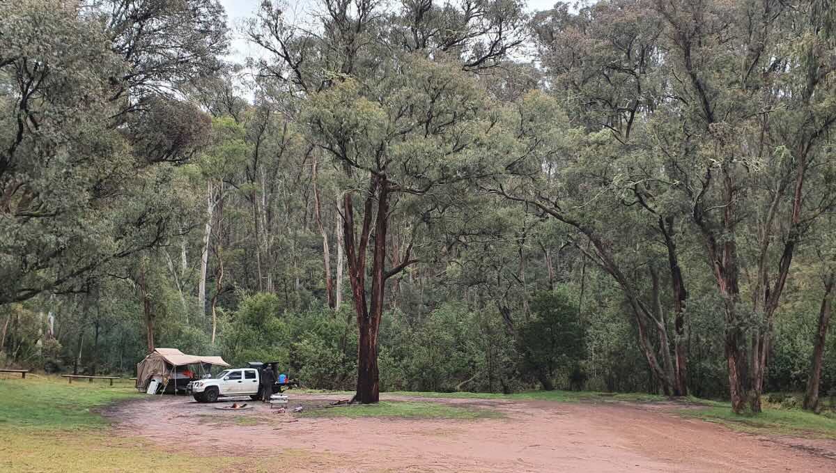
Nestled in the tranquil, high-country woodlands of Merrijig, Victoria, Buttercup 3 Campground offers a serene and rustic escape for those seeking to reconnect with nature. This free, dog-friendly bush camp provides a peaceful base from which to explore the magnificent Victorian High Country, with its well-regarded facilities and scenic surroundings. The campground is consistently praised for its quiet ambience and the abundant native birdlife that makes it a favourite spot for couples and small groups. Buttercup 3 is an ideal location for a self-sufficient camping experience, offering a simple yet beautiful setting to unwind.
The site is accessible by camper trailers and offers a good balance of seclusion and convenience. It serves as a fantastic launching point for an array of outdoor pursuits, including bushwalking, horse riding, mountain biking, and four-wheel driving. The tumbling water of Buttercup Creek provides a soothing soundtrack to your stay. While the campground offers essential amenities, visitors are advised to come prepared with their own supplies to ensure a comfortable and enjoyable stay in this pristine natural environment. With its clean, well-maintained facilities and picturesque location, Buttercup 3 Campground is a hidden gem that promises a truly memorable alpine camping adventure.
Buttercup 3 Campground – VIC Location Map
Buttercup 3 Campground
Address: Merrijig Drive, Merrijig VIC 3723
GPS Coordinates: -37.068668133915864, 146.33881120356187
Site Information & Local Amenities
- Location: A free bush camp located at the Buttercup Creek camping area near Merrijig, Victoria.
- Site Suitable For: Tents and camper trailers.
- Road Access: Two-wheel drive access is via Carter’s Road off Mt Buller Road. Four-wheel drives can use Buttercup Road to access the campsites.
- Site Surface: Dirt/gravel.
- Camping Permitted: Yes, this is a free public campground.
- Maximum Overnight Stays: Unspecified, but generally a reasonable length of stay is permitted.
- Facilities: Public toilets, picnic tables, fire pits.
- Potable Water: No. Bring your own drinking water. Non-potable water may be available from the creek.
- Mobile Phone Coverage: Very limited to no coverage depending on provider. Telstra and Optus may have some patchy 4G. A satellite phone is recommended for emergencies.
- TV Reception: Likely to be very poor to non-existent due to the remote location.
- Onsite Public Toilets: Yes.
- Rubbish Bins: No. Take all your rubbish with you.
- Open Fires: Permitted in designated fire pits, subject to fire restrictions. Check local conditions.
- Generator Use: Permitted.
- Number of Sites Available: Multiple small, shady sites are available.
- Essentials to Bring: Drinking water, all food supplies, rubbish bags, portable power/light source.
- Pet Friendly: Yes, dogs are permitted.
- Fishing: Fishing may be possible in nearby creeks or rivers.
- Short Walks: Excellent access for bushwalking trails in the surrounding state forest.
- Name and Distance to 3 Local Pubs:
- Merrijig Hotel: Approximately 10 km.
- The Mill Inn Restaurant & Pub: Approximately 15 km.
- The Hunt Club Hotel: Approximately 20 km.
- Name and Distance to Places to Eat:
- The Mill Inn Restaurant: Approx. 15 km.
- Merrijig Kitchen Cafe: Approx. 10 km.
- Peaks Restaurant (at The Sebel Pinnacle Valley): Approx. 20 km.
- Name and Distance to Local Attractions:
- Mount Buller: Approx. 30 km.
- Howqua Hills Historic Area: Approx. 25 km.
- Craig’s Hut: Approx. 40 km (4WD access required).
- Name and Distance to Nearest Caravan Parks:
- Mansfield Holiday Park: Approx. 25 km.
- Bonnie Doon Caravan Park: Approx. 40 km.
- Name and Distance to Next Free Camps:
- Buttercup 2 Campground: A short walk away.
- Plain Creek Camping Area: Approx. 5 km.
- Sheepyard Flat: Approx. 20 km.
- Name and Distance to Nearest Dump Points:
- Mansfield Township: Approx. 25 km.
- Name and Distance to Nearest Petrol Station:
- Mirimbah: Approx. 13 km.
- Mansfield: Approx. 19 km.
- Name and Distance to Drinking Water Resupply:
- Mansfield Township: Approx. 25 km.
- Name and Distance to Public Toilets:
- Merrijig Hall: Approx. 10 km.
- Mansfield Township: Approx. 25 km.
- Seasonal Weather Forecast:
- Spring (Sep-Nov): Variable weather with cool mornings, mild days, and a chance of showers. Snow can still fall at higher elevations.
- Summer (Dec-Feb): Warm to hot days, cooler nights. High fire danger periods.
- Autumn (Mar-May): Pleasant, cool days and cold nights. A popular time for camping with stunning autumn colours.
- Winter (Jun-Aug): Cold and wet with snow at higher elevations. Camping is not recommended for those without proper equipment.