Talbotville Camping Area, Historic 4WD Camping near Dargo
Step back in time at Talbotville Camping Area, one of the Victorian High Country’s most iconic and cherished destinations for 4WD adventurers and history buffs. Situated on the site of a former gold rush town, this sprawling, grassy plain nestled alongside the Crooked River offers a unique blend of historical intrigue and natural beauty. Accessing Talbotville is a classic High Country experience, typically undertaken via the Crooked River Track from Dargo. This route is strictly for high-clearance 4WD vehicles and involves numerous river crossings that vary in depth depending on the season and recent rainfall. This challenging yet scenic journey ensures the area remains a sanctuary for those truly seeking to immerse themselves in the remote alpine environment.
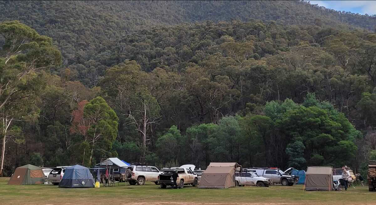
Once a bustling town with pubs, shops, and a police station, all that remains of Talbotville today are the vast, open flats that are perfect for camping. The sheer size of the area makes it a favourite for large groups and families, with ample space to spread out and find a private spot by the river. The atmosphere is one of peaceful isolation, punctuated by the sounds of the flowing river and the crackle of a campfire. Activities at Talbotville are simple and rewarding: fishing for trout, swimming in the crisp river pools, exploring the remnants of the old town site, or simply relaxing and soaking in the magnificent mountain scenery. As a primitive campground within the Grant Historic Area, facilities are limited to basic toilets. Campers must be entirely self-sufficient, carrying in all their food, water, and supplies, and strictly adhering to ‘leave no trace’ principles to preserve this special place. For those equipped for the journey, a trip to Talbotville is a pilgrimage into the heart of Victoria’s pioneering past.
Talbotville Camping Area – VIC Location Map
Campground Details
- Name: Talbotville Camping Area
- Address: 11 Crooked River Track, Wongungarra VIC 3862
- GPS Coordinates: -37.33396, 147.06659
- Location: Large, open, grassy flats on the banks of the Crooked River, on a historic town site.
- Site Suitable For: Tents, swags, off-road camper trailers, and off-road caravans. Excellent for groups.
- Road Access: Strictly 4WD only. Access involves multiple river crossings on the Crooked River Track which can become impassable.
- Site Surface: Mostly grass and dirt.
- Camping Permitted: Yes.
- Maximum Overnight Stays: Check with Parks Victoria for current information.
- Number of Powered Sites: 0.
- Number of Un-powered Sites: Hundreds of informal, unmarked sites.
Facilities
- Picnic Tables: No.
- Potable Water: No. Bring all your own water or be prepared to treat river water.
- Mobile Phone Coverage: No. A satellite communication device is highly recommended.
- TV Reception: No.
- Onsite Public Toilets: Yes, multiple non-flush pit toilets are located around the area.
- Rubbish Bins: No. All rubbish must be taken out with you.
- Open Fires: Permitted in existing fireplaces, subject to seasonal fire restrictions and Total Fire Bans.
- Generator Use: Permitted, but considerate use is requested due to the open nature of the area.
- Number of Sites Available: Not individually marked.
Activities & Important Information
- Essentials to Bring: Drinking water, 4WD recovery gear (including a snorkel), firewood, portable toilet (optional but preferred), and a satellite phone.
- Pet Friendly: Yes, dogs on a leash are generally permitted, but confirm with current Parks Victoria guidelines.
- Fishing: Popular in the Crooked River for trout. A Victorian fishing licence is required.
- Short Walks: Explore the expansive flats, wander along the river, and imagine the historic town that once stood here.
Local Amenities
The nearest town for fuel, food, and supplies is Dargo. It is essential to be fully self-contained before beginning the trip to Talbotville.
Pubs & Places to Eat
- The Dargo Hotel: Approximately 25-30 km away. The drive is slow, involving unsealed tracks and river crossings.
- Dargo River Inn: Also in Dargo, approximately 25-30 km away.
Local Attractions
- Grant Historic Area: The broader area contains numerous relics from the gold rush era.
- Wonnangatta Station Drive: A famous and very challenging multi-day 4WD trip for experienced drivers, which can be started from this area.
- Iconic 4WD Tracks: Close to legendary tracks like Billy Goat Bluff, Blue Rag Range, and the Pinnacles.
Camping & Services
- Nearest Caravan Parks: Dargo River Inn & Tourist Park (approx. 25 km).
- Next Free Camps: Eaglevale, Black Snake Creek, Italian Flat, all located along the Crooked River Track.
- Nearest Dump Points: Bairnsdale or Stratford.
- Nearest Petrol Station: Dargo (check for limited operating hours).
- Drinking Water Resupply: Dargo.
- Nearest Public Toilets (Flush): Dargo.
Seasonal Weather Forecast
Crucial: Access is heavily dependent on weather and river levels. Tracks are subject to seasonal closures (usually from the King’s Birthday weekend in June to the end of October). Always check Parks Victoria for road status.
- Summer (Dec-Feb): Warm to hot days are perfect for river activities. High risk of bushfires.
- Autumn (Mar-May): Considered the prime season with mild, stable weather and beautiful scenery.
- Winter (Jun-Aug): Very cold. Tracks are closed, and the area is inaccessible to vehicles.
- Spring (Sep-Nov): Cool and unpredictable. Tracks may remain closed, and the river is often high and dangerous due to snowmelt.