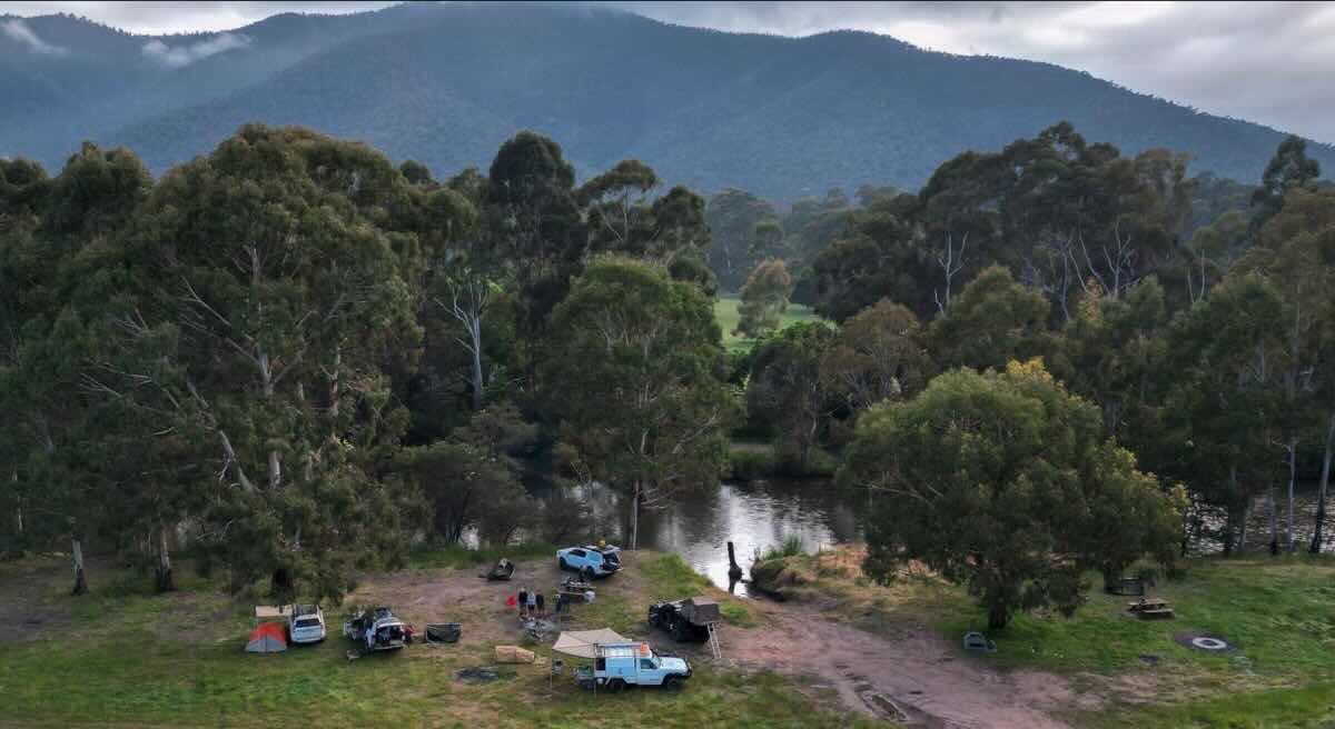
Eaglevale Camping Area, 4WD Riverside Camping near Dargo
Immerse yourself in the rich gold rush history of the Victorian High Country at Eaglevale Camping Area, a remote and rewarding destination for the well-prepared 4WD enthusiast. Located on the banks of the legendary Crooked River and accessible via the challenging Eaglevale Track, this campsite is a true escape into the wilderness. The journey in is part of the adventure, requiring a high-clearance 4WD to navigate the steep, rocky, and often narrow track that descends to the river valley. This challenging access ensures that Eaglevale remains a peaceful and uncrowded haven for those who make the effort. The campground itself consists of several flat, grassy clearings spread along the river, offering serene spots to set up a self-sufficient camp.
This area is steeped in the history of the 19th-century goldfields, and relics of the past can be found by those with a keen eye. The main activities revolve around the pristine river environment and the surrounding rugged terrain. Anglers can try their luck fishing for trout in the clear waters of the Crooked River, while others might enjoy a refreshing swim on a warm day. The area is also popular for recreational gold prospecting, with many visitors hoping to find a fleck of colour. As a primitive bush camp, there are minimal facilities. Campers must adhere to the ‘leave no trace’ principle, bringing in all their own supplies—including drinking water and a portable toilet—and taking all rubbish back out. With no mobile reception, it’s a genuine opportunity to disconnect from modern life and reconnect with nature in a spectacular and historically significant part of Victoria.
Eaglevale Camping Area – VIC Location Map
Campground Details
- Name: Eaglevale Camping Area
- Address: Eaglevale Track, Crooked River VIC 3862
- GPS Coordinates: -37.36566, 147.00502
- Location: Nestled on the banks of the Crooked River, deep in a remote valley.
- Site Suitable For: Tents, swags, and rugged off-road camper trailers. Not suitable for caravans or large campervans.
- Road Access: Eaglevale Track is strictly 4WD only, featuring steep and difficult sections. Not recommended in wet weather.
- Site Surface: Natural grass and dirt.
- Camping Permitted: Yes.
- Maximum Overnight Stays: Check with Parks Victoria for current information.
- Number of Powered Sites: 0.
- Number of Un-powered Sites: Multiple unmarked, informal sites.
Facilities
- Picnic Tables: No.
- Potable Water: No. You must bring all your own water. River water should be treated before use.
- Mobile Phone Coverage: No. Expect zero reception. A satellite communication device is recommended.
- TV Reception: No.
- Onsite Public Toilets: Yes (a basic non-flush pit toilet may be present). A personal portable toilet is highly recommended.
- Rubbish Bins: No. This is a carry-in, carry-out site.
- Open Fires: Permitted in existing fireplaces, subject to seasonal fire restrictions. Bring your own firewood.
- Generator Use: Permitted, but considerate use is requested.
- Number of Sites Available: Not individually marked.
Activities & Important Information
- Essentials to Bring: Drinking water, firewood, 4WD recovery gear, portable toilet, first-aid kit, and a satellite phone or PLB.
- Pet Friendly: Yes, dogs on a leash are generally permitted in historic areas, but confirm with Parks Victoria guidelines.
- Fishing: Trout fishing is popular in the Crooked River (Victorian fishing licence required).
- Short Walks: Explore the river banks and old mining areas.
Local Amenities
The nearest town with comprehensive services is Dargo. Ensure you are fully fuelled and supplied before heading into the bush.
Pubs & Places to Eat
- The Dargo Hotel: Approximately 30-35 km away. The drive is slow and on mountainous/unsealed roads.
- Dargo River Inn: Also located in Dargo, approximately 30-35 km away.
Local Attractions
- Grant Historic Area: Explore the remnants of a once-thriving gold rush town.
- Talbotville Camping Area: Another historic and popular 4WD destination nearby.
- Billy Goat Bluff Track: One of the High Country’s most iconic and challenging 4WD tracks is accessible from this region.
Camping & Services
- Nearest Caravan Parks: Dargo River Inn & Tourist Park (approx. 30 km).
- Next Free Camps: Talbotville, Italian Flat, Black Snake Creek.
- Nearest Dump Points: Bairnsdale or Stratford.
- Nearest Petrol Station: Dargo (check operating hours).
- Drinking Water Resupply: Dargo.
- Nearest Public Toilets (Flush): Dargo.
Seasonal Weather Forecast
Crucial: Weather conditions dictate track safety. Access tracks can be closed seasonally (typically from June to November). Always check road closures before you go.
- Summer (Dec-Feb): Days are warm to hot, ideal for river activities. High fire danger season.
- Autumn (Mar-May): Generally the best time to visit, with mild weather, stable track conditions and beautiful colours.
- Winter (Jun-Aug): Very cold. Tracks are closed due to snow, ice, and wet conditions. The area is generally inaccessible.
- Spring (Sep-Nov): Cool and potentially wet. Tracks may remain closed until late in the season. River levels can be high.