8 Mile Flat Campsite, Alpine National Park
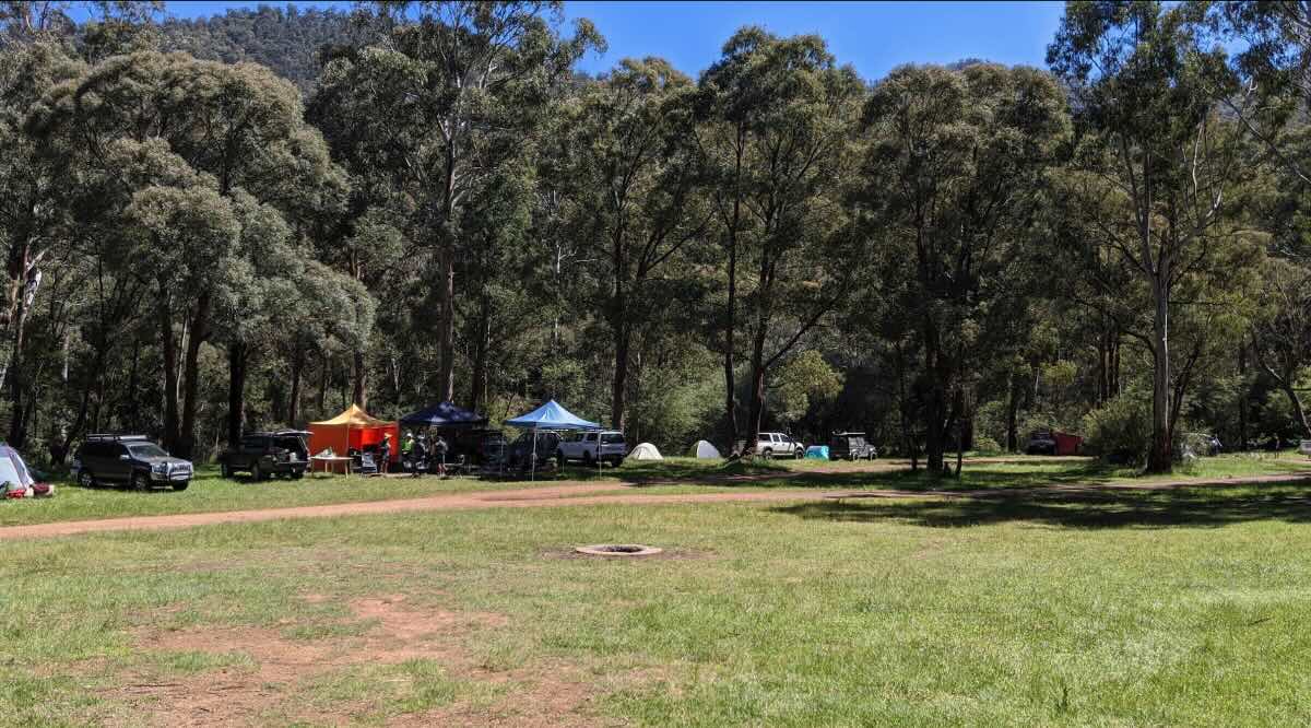
Venture deeper into the legendary Howqua Hills and you’ll be rewarded with the secluded beauty of 8 Mile Flat, a free campground for the more adventurous spirit. Located within the boundaries of the Alpine National Park, this campsite offers a more remote and rugged experience than the easily accessible flats further downstream. Reaching this idyllic spot typically requires a high-clearance 4WD, as the track involves several river crossings that vary in depth depending on the season and recent rainfall. The journey itself is part of the adventure, taking you through some of Victoria’s most spectacular high country scenery. The campground is a beautiful, spacious grassy flat nestled in a bend of the Howqua River, surrounded by towering gum trees and steep, forested ranges. It provides a genuine sense of isolation and a true bush camping atmosphere.As this site is within a national park, stricter rules apply: dogs and generators are not permitted, ensuring a peaceful environment for all campers and the protection of native wildlife. The facilities are basic, consisting of a non-flush toilet block, but the natural amenities are second to none. The crystal-clear Howqua River is perfect for swimming and fishing for trout, and the surrounding area is a paradise for hikers and 4WD explorers, serving as a popular starting point for the walk to the historic Gardiners Hut (formerly Eagles Peaks Hut). Campers must be completely self-sufficient, bringing in all food, drinking water, and equipment, and must pack out all rubbish. Fires are permitted in the designated fireplaces, but campers need to bring their own firewood and be vigilant about fire bans. For those with a capable vehicle and a desire to escape the crowds, 8 Mile Flat is a magnificent destination that encapsulates the wild, untamed spirit of the Victorian High Country.
8 Mile Flat Campsite – VIC Location Map
- Name and Address: 8 Mile Flat Campsite, 8 Mile Gap Road, Howqua Hills, VIC 3723, Australia
- GPS Coordinates: -37.19833764145215, 146.42891871214053
- Website: Parks Victoria – Alpine National Park
Campground Information & Features
- Location: In the Alpine National Park, upstream from Sheepyard Flat on the Howqua River.
- Site Suitable For: Tents, swags, and high-clearance off-road camper trailers.
- Road Access: 4WD only. Involves multiple river crossings which can be deep and impassable after rain.
- Site Surface: Large, flat, grassy area.
- Camping Permitted: Yes, free camping, no bookings.
- Maximum Overnight Stays: Standard national park limits apply.
- Facilities: Non-flush toilets, picnic tables, fireplaces.
- Potable Water: No. Bring your own drinking water or be prepared to treat river water.
- Mobile Phone Coverage: None.
- Onsite Public Toilets: Yes, non-flush toilets are available.
- Rubbish Bins: No. All rubbish must be carried out.
- Open Fires: Permitted in designated fireplaces, subject to fire bans. No firewood collection permitted.
- Generator Use: Prohibited within the Alpine National Park.
- Number of Sites Available: Plenty of unmarked sites on a large flat.
- Essentials to Bring: Drinking water, firewood, rubbish bags, toilet paper, vehicle recovery gear.
- Pet Friendly: No. Dogs are not permitted in the Alpine National Park.
- Fishing: Excellent trout fishing in the Howqua River.
- Short Walks: This is a popular start point for the walk to Gardiners Hut / Eagles Peaks.
Nearby Amenities & Attractions
- Local Pubs:
- Jamieson Brewery and Grill (Jamieson) – Approx. 45 km
- Courthouse Hotel (Jamieson) – Approx. 45 km
- The Delatite Hotel (Mansfield) – Approx. 50 km
- Places to Eat:
- Jamieson (Various cafes and hotel) – Approx. 45 km
- Mansfield (Wide variety of cafes, bakeries, pubs, restaurants) – Approx. 50 km
- Merrijig Motor Inn & Bistro – Approx. 40 km
- Local Attractions:
- Gardiners Hut (Eagles Peaks Hut)
- Howqua Hills Historic Area (Fry’s Hut, Sheepyard Flat) – Approx. 15 km downstream
- The Bluff and other 4WD tracks
- Nearest Caravan Parks:
- Howqua Valley Holiday Park – Approx. 30 km
- Jamieson Caravan Park – Approx. 45 km
- Mansfield Holiday Park – Approx. 50 km
- Next Free Camps:
- 7 Mile Flat – Downstream
- Sheepyard Flat – Approx. 15 km downstream (2WD accessible)
- Fry’s Flat – Approx. 17 km downstream (2WD accessible)
- Nearest Dump Points:
- Mansfield Public Dump Point – Approx. 50 km
- Nearest Petrol Station:
- Mansfield (Multiple major service stations) – Approx. 50 km
- Jamieson General Store – Approx. 45 km
- Drinking Water Resupply:
- Mansfield is the nearest reliable town with public taps.
- Nearest Public Toilets (offsite):
- 7 Mile Flat (downstream)
- Sheepyard Flat (downstream) – Approx. 15 km
Seasonal Weather Forecast: Howqua Hills / High Plains Area
- Summer (Dec-Feb): Warm to hot days, ideal for swimming. Alpine weather can change quickly. Temperatures from 12°C to 30°C+.
- Autumn (Mar-May): Generally the best time to visit, with stable weather and beautiful colours. River crossings are usually lower. Temperatures from 5°C to 22°C.
- Winter (Jun-Aug): Inaccessible. Tracks are closed due to snow and hazardous conditions.
- Spring (Sep-Nov): Tracks often remain closed until late spring. River crossings can be dangerously high. Cold and unpredictable weather.