Starlings Gap Campground, Historic 4WD Free Camping in the Yarra Ranges
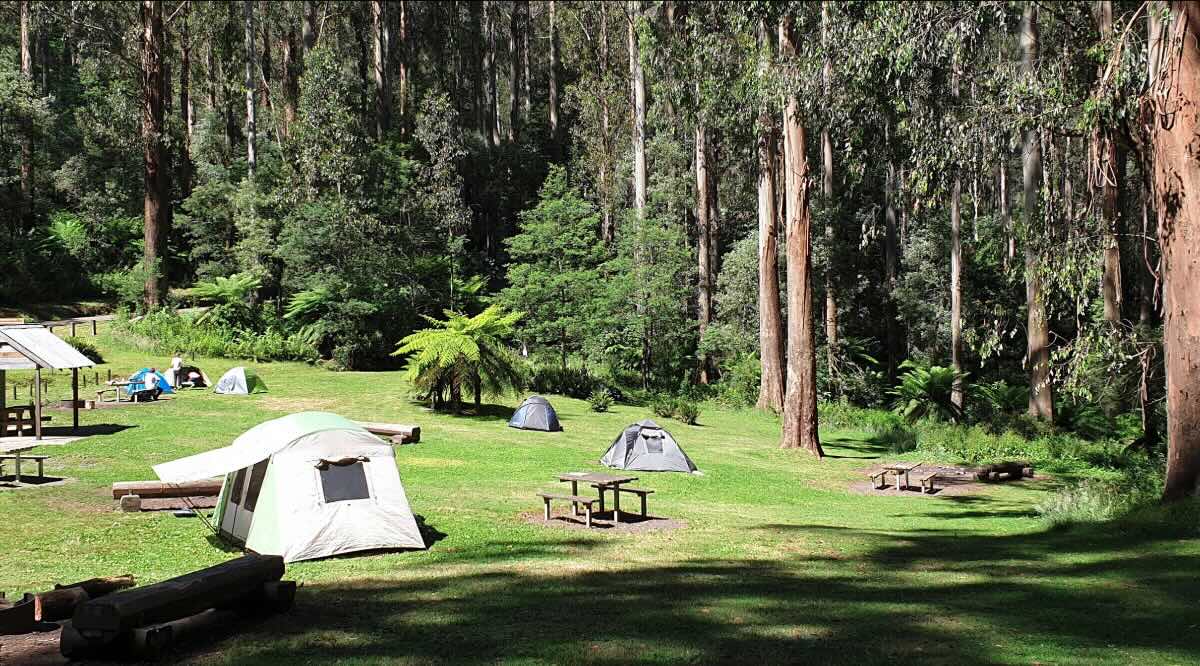
Journey deep into the magnificent mountain ash forests of the Yarra State Forest to discover Starlings Gap Campground, a historic and remote free camping area that offers a genuine High Country adventure. Once a bustling timber milling settlement, this beautiful clearing is now a tranquil haven for self-sufficient campers and 4WD enthusiasts. The journey to Starlings Gap is part of the experience, requiring a well-equipped vehicle to navigate the unsealed, and often steep and slippery, forest tracks that lead to this secluded spot. The reward is a stunning campsite surrounded by some of the world’s tallest flowering plants and lush, temperate rainforest filled with tree ferns.
The campground itself is a large, open grassy area with a number of dispersed sites suitable for tents, swags, and off-road camper trailers. History is all around, with a historic steel boiler from the old mill days standing as a silent monument to the area’s industrial past. The facilities are basic, with a non-flush toilet and communal fire pits, reinforcing the back-to-basics nature of the camp. As a state forest campground, Starlings Gap is a pet-friendly location, making it an excellent choice for those who want to explore the rugged trails with their dogs. Campers must be fully self-contained, bringing their own drinking water and taking all rubbish home. The high altitude and dense forest mean mobile phone reception is virtually non-existent, providing a perfect opportunity to disconnect. For those prepared for a true 4WD adventure, Starlings Gap offers a unique blend of history, solitude, and spectacular natural beauty.
Starlings Gap Campground – VIC Location Map
Campground Information
- Name: Starlings Gap Campground
- Address: Starlings Gap Road, Powelltown, VIC 3797, Australia
- GPS Coordinates: -37.814247610986314, 145.80097295298057
- Website: Managed by Forest Fire Management Victoria (no dedicated site).
Features & Facilities
- Location: Remote high-altitude setting in the Yarra State Forest.
- Site Suitable For: Tents, swags, and off-road camper trailers.
- Road Access: Difficult 4WD access only. Tracks are steep, often slippery, and subject to seasonal closures.
- Site Surface: Grass and dirt.
- Camping Permitted: Yes, free camping.
- Maximum Overnight Stays: Standard state forest limits apply.
- Facilities: Non-flush toilet, picnic tables, fire pits.
- Potable Water: No. Bring your own or treat local creek water.
- Mobile Phone Coverage: None. An emergency communication device is essential.
- Onsite Public Toilets: Yes, a non-flush toilet is available.
- Rubbish Bins: No. Carry-in, carry-out policy applies.
- Open Fires: Permitted in designated pits, subject to local fire restrictions.
- Generator Use: Permitted, with consideration for other campers.
- Number of Sites Available: Numerous unmarked, dispersed sites.
- Essentials to Bring: All water, food, firewood, rubbish bags, recovery gear, and an emergency communication device.
- Pet Friendly: Yes, pets are permitted on a leash.
- Fishing: Limited opportunities in small local creeks.
- Short Walks: Access to the historic Walk into History trail and other 4WD tracks.
Local Amenities & Attractions
- Local Pubs:
- Powelltown Hotel – approx. 25 km
- Noojee Hotel – approx. 30 km
- The Independent (Gembrook) – approx. 50 km
- Places to Eat:
- Powelltown Sawmill Cafe – approx. 25 km
- The Outpost (Noojee) – approx. 30 km
- Local Attractions:
- Walk into History Trail
- Ada Tree (giant Mountain Ash)
- Powelltown Tramway Walk
- Noojee Trestle Bridge
Nearby Parks & Services
- Nearest Caravan Parks:
- Powelltown Caravan Park – approx. 25 km
- Rawson Caravan Park – approx. 40 km
- Nearest Alternate Free Camps:
- Latrobe River Campground
- Coopers Creek Campground (near Walhalla)
- Nearest Dump Points:
- Yarra Junction Public Dump Point – approx. 45 km
- Moe Public Dump Point – approx. 60 km
- Nearest Petrol Station: Powelltown or Noojee.
- Nearest Drinking Water Resupply: Powelltown or Noojee.
- Nearest Public Toilets: Available onsite.
Seasonal Weather Forecast
- Summer (Dec-Feb): Mild to warm days with cool alpine nights. Average maximums are around 23°C.
- Autumn (Mar-May): Cool, crisp days and cold nights. The forest colours are spectacular. Average maximums range from 13°C to 20°C.
- Winter (Jun-Aug): Very cold. Tracks are often closed due to snow and hazardous, slippery conditions. Average maximums are around 9°C.
- Spring (Sep-Nov): Cool days. Tracks can remain closed until late spring. Average maximums range from 13°C to 18°C.
